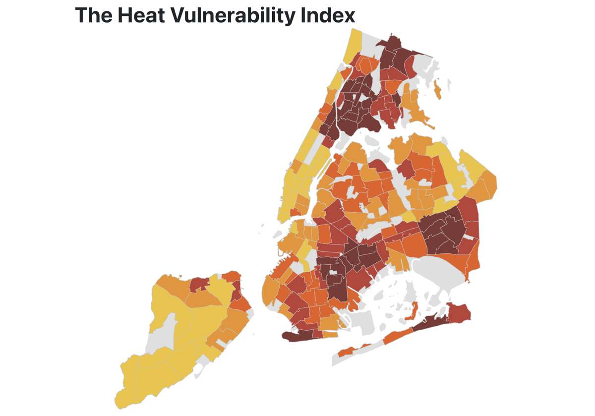
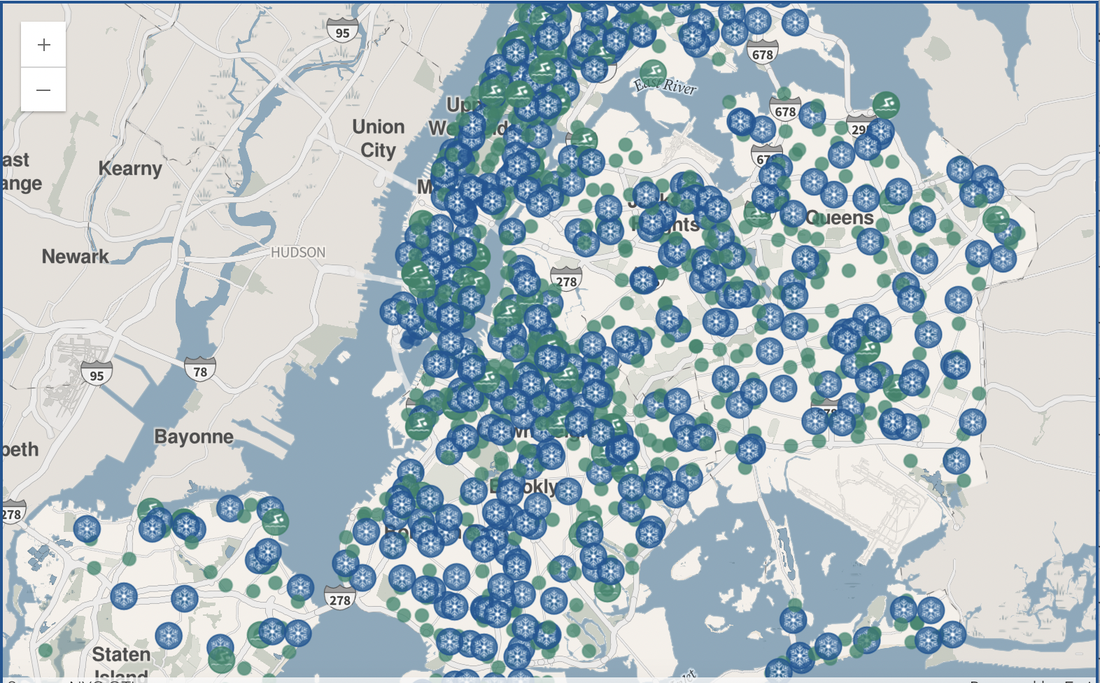
NYC FAITH SECTOR CLIMATE ADAPTATION WORKING GROUP
Faith communities are often the first responders in emergencies. The anchor institutions that keep communities together are vital for the planning of the future; however, they often do not have the resources or capacity to support this work. Rebuild by Design and New York Disaster Interfaith Services (NYDIS) are convening an interfaith advisory group on long-term climate adaptation planning that opens the door to dialogues about making space for current and new neighbors, building climate resilience through interfaith networks, accessing funding for planning ahead, and embedding values about how one’s faith compels to climate action, and long term planning for climate migration, in day to day conversations.
THE PROGRAM
Through a 6-month process between April and September 2025, a cohort of NYC faith leaders will work together, alongside climate specialists, to build their capacity to communicate with their constituencies about climate hazards, disaster preparedness, and long-term climate adaptation planning. Our goals:
- LEARN: Visit with faith communities and climate specialists to learn first-hand about the needs and challenges related to climate hazards facing local communities
- COLLABORATE: Exchange knowledge to catalyze faith sector collaboration around climate adaptation & disaster preparedness.
- COMMUNICATE: Inform the creation of a faith sector tool kit to communicate climate risk and solutions to diverse faith communities.
INTERACTIVE MAPS: IDENTIFYING RISK & VULNERABILITY
The Heat Vulnerability Index (HVI) shows neighborhoods whose residents are more at risk for dying during and immediately following extreme heat. It looks at the most important factors of neighborhood heat risk: surface temperature, green space, home air conditioning, and income.
Created by NYC.
Explore HERE >>
The City has created four rainfall-based flooding maps. The maps show limited stormwater flooding under current sea level rise conditions, moderate stormwater flooding scenarios under current and future sea level rise conditions, as well as an extreme stormwater flooding scenario under future conditions.
Created by NYC.
Explore HERE>>
NYC’s Hurricane Evacuation Zone Finder helps residents find out if their address is in a hurricane evacuation zone. The map provides a color-coded system and number labels: 1, 2, 3, 4, 5, and 6.
The map also provides information about hurricane evacuation centers.
Created by NYC.
Explore Here >>
The EJNYC Mapping Tool equips all New Yorkers with information necessary to advocate for and make more informed decisions about environmental justice in New York City.
This tool provides information about climate vulnerability, air quality, housing, hazardous materials, and health.
Created by NYC.
Explore HERE>>
The NYC Flood Hazard Mapper provides a comprehensive overview of the coastal flood hazards that threaten the city today, as well as how these hazards are likely to increase in the future.
Created by NYC.
Explore HERE>>
The Atlas of Accountability (Disaster) maps federal major disaster declarations and federal post-disaster assistance obligations for every county in the United States, with an overlay of congressional district boundaries.
Explore HERE>>
The Climate Displacement in NYC map shows areas with high risk of displacement due to the direct or indirect impacts of coastal flooding. The map also identifies areas that are less likely to be impacted by climate risks and population shifts, as well as areas that may see an increase in population due to low risk.
Created by Rebuild by Design.
Explore Here >>
The “Who lives in the NYC Floodplain?” map identifies the demographic characteristics of residents living in the current and future coastal floodplains in NYC. Specifically, the map breaks down the income, race and ethnicity of residents living in these at risk areas.
Created by Rebuild by Design.
Explore HERE>>