ABOUT Unlock Alameda Creek

Public Sediment for Alameda Creek is an implementable project that links Alameda Creek with its historic baylands. It provides a sustainable supply of sediment to bay marshes and mudflats for sea level rise adaptation, reconnects migratory fish with their historic spawning grounds, and introduces a network of community spaces that reclaim the creek as a place for people, building an ethos and awareness around our public sediment resources.

READ THE FULL UNLOCK ALAMEDA CREEK REPORT HERE

WATCH THE UNLOCK ALAMEDA CREEK FINAL PRESENTATION

Where

PUBLIC SEDIMENT FOR ALAMEDA CREEK is a proposal to address the challenge of sediment scarcity along the vulnerable urban edges of Fremont, Union City, and Newark. The baylands require sediment to keep pace with sea level rise, yet sediment is trapped upstream in dams and flood control channels. To bring sediment to the baylands, we look upstream to Alameda Creek, the largest local tributary that feeds the Bay. Our proposal aims to redesign this waterbody to create functional systems that sustainably transport sediment, engage people, and provide habitat for anadromous fish.

What

Our team proposes that sea level rise adaptation must happen upstream, in tributaries. Public Sediment for Alameda Creek unlocks the creek to feed downstream baylands with sediment and sustain protective tidal ecosystems as the climate changes. Our project moves beyond the tidal edge to span four geographies (uplands, creek, baylands, and bay) and results in three proposals: UNLOCK ALAMEDA CREEK is an implementable project that links the creek with the baylands. It provides a sustainable supply of sediment to baylands for sea level rise adaptation, reconnects migratory fish with their historic spawning grounds, and introduces a network of community spaces that reclaim the creek as a place for people, building an ethos and awareness around our public sediment resources. RETHINK THE SEDIMENTSHED is a long-term, multi-agency planning and visioning process for the sedimentshed of Alameda Creek that balances creek inputs with bayland needs over time. The planning process would develop strategies to rethink upland dam and reservoir infrastructure, to harvest sediment and move it downstream. It would quantify and monitor the sediment needs of the changing baylands. PLAN + PILOT FOR A FUTURE BAY proposes that we plan now for the future of all the San Francisco baylands with low sediment supply and sea level rise. We propose a design-science collaboration that explores new scenarios of sediment management for the Bay, articulating the physical realities, social dimensions, and long-term landscape implications of investing differently with mud. This process will establish a joint vision for bayland sediment sustainability and develop a series of pilots to guide investment over time with greater rates of sea level rise.

Why

The Bay’s marshes and mudflats are multi-benefit resources. They provide habitat, cushion the urban edges of Alameda County from extreme storms and tidal events, filter water, and sequester carbon. Yet these resources are at risk – land subsidence and sea level rise threaten to damage or destroy the Bay’s marshes and mudflats by 2100. Projections show that with 3.5’ of sea level rise by 2100, the region’s current sediment supply will not sustain these ecosystems over time. Without sediment, our baylands will drown. This represents a slow but devastating scale of loss that threatens ecosystems, recreational landscapes, and places hundreds of thousands of residents and the region’s critical drinking water, energy, and transportation systems at risk. PUBLIC SEDIMENT FOR ALAMEDA CREEK is a systemic proposal for action in the Alameda Creek watershed that address the challenge of sediment scarcity along the vulnerable urban edges of Fremont, Union City, and Newark.

The Team

PUBLIC SEDIMENT is a multidisciplinary design team that views sediment as a core building block of resilience in San Francisco Bay. The team is led by SCAPE Landscape Architecture with Arcadis, the Dredge Research Collaborative, TS Studio, the UC Davis Department of Human Ecology and Design, Cy Keener, and the Architectural Ecologies Lab. PUBLIC SEDIMENT FOR ALAMEDA CREEK builds on and connects ongoing efforts in the region, including the work of the Alameda County Flood Control and Water Conservation District, the South Bay Salt Pond Restoration Project, the Alameda Creek Alliance, the East Bay Regional Park District, and many others.

Next Steps

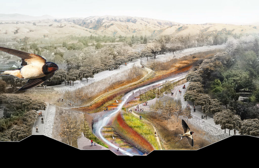
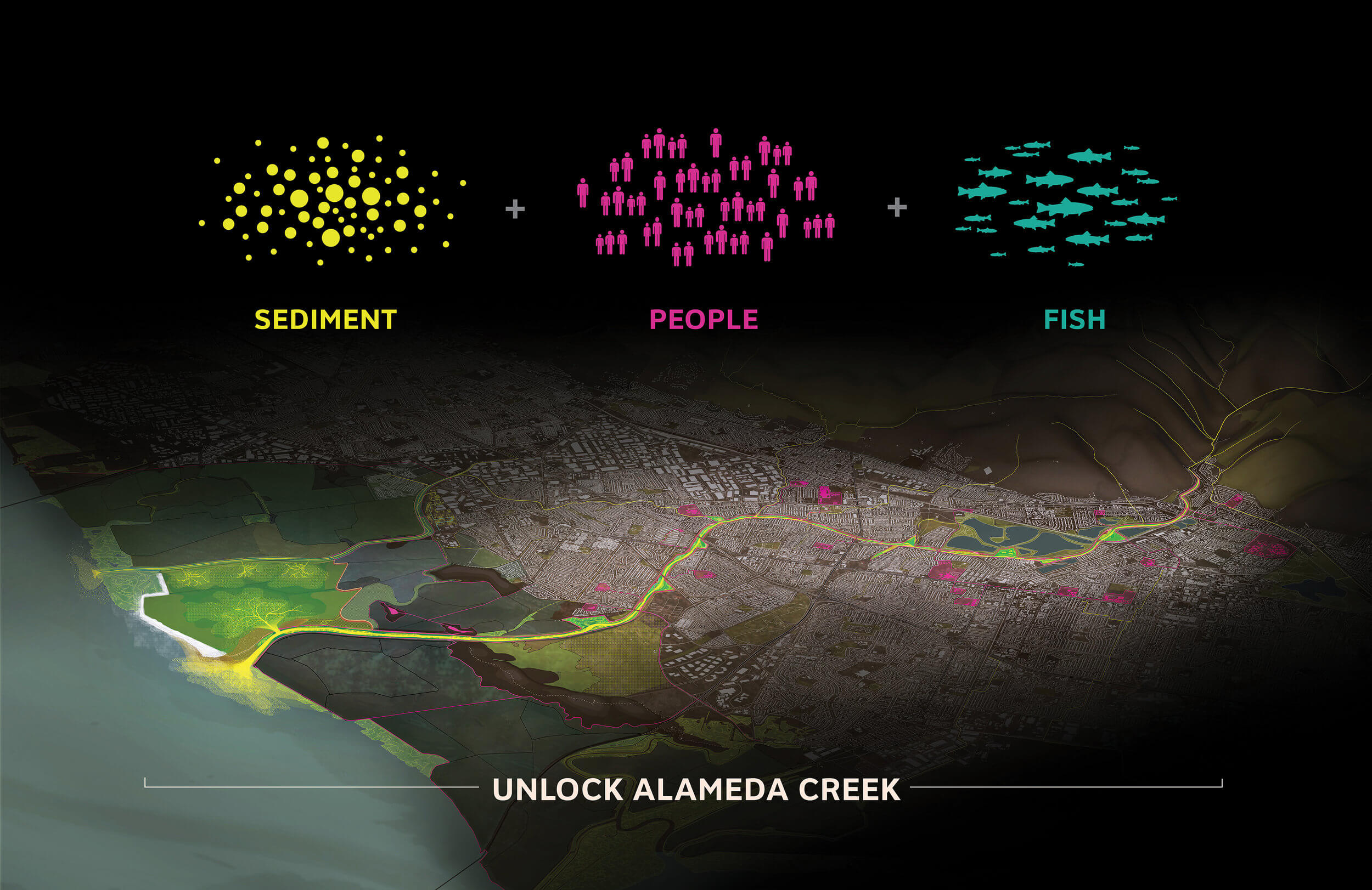
Measure AA, intended to restore Bay Area wetlands, passed as an example of a truly regional ballot measure. Our team builds on this momentum and investment in ecological infrastructure to propose Unlock Alameda Creek, a tributary-based methodology for bayland nourishment. This project is implementable today and stitches together ongoing initiatives in the watershed identified by the Alameda County Flood Control and Water Conservation District, the South Bay Salt Pond Restoration Project, the East Bay Regional Park District, the Coastal Conservancy, and the Alameda Creek Alliance.

Alameda Creek is the beginning of a larger regional effort to reconsider and reinvest in tributaries as functional ecological systems. Public Sediment for Alameda Creek represents a paradigm shift in how we plan for climate change – rather than hardening the edge and ignoring the long-term consequences, we must recalibrate our relationship with sediment and water resources and invest today in living systems that will grow over time to adapt to sea level rise. Public Sediment for Alameda Creek is a proposal for unlocking and remaking broken systems, and we must apply this thinking at other scales– to the necklace of tributaries that feeds the Bay, to the Delta and the larger Rivers of California. Our risks are invisible yet they increase dramatically over time – we must invest now in functional tributaries that sustain living bayland infrastructure for the future.

Translate