ABOUT ISLAIS HYPER-CREEK

Today, the basin of Islais Creek–an historic watershed-turned-industrial district in San Francisco, built on rubble from a 1906 earthquake–is at risk from coastal and stormwater flooding, as well as liquefaction.

Islais Hyper-Creek is a vision for the area where ecology and industry co-exist in harmony. A large park with a restored tidal creek system and soft shoreline shares the area with maritime functions, light manufacturing, and logistics that have formed the area’s economic backbone for decades. This park plays an important role in building physical and social resilience: it retains, conveys and cleans water, protecting the surrounding neighborhoods while providing amenities and benefits to the community. Present-day industrial functions are consolidated in a smaller area, clustered with complementary programs. This increases their efficiency and provides new economic opportunities.

Six proposed pilot projects, developed together with stakeholders and local communities, will kickstart a long-term process toward realizing the overall vision.

WATCH THE ISLAIS HYPER-CREEK FINAL PRESENTATION

READ THE FULL ISLAIS HYPER-CREEK REPORT HERE

Where

Islais Hyper-Creek is located at the juncture of many diverse neighborhoods, including Bayview-Hunters Point, Dogpatch, and Potrero Hill. Notably, the area is a nexus for working-class industrial jobs as well as food distribution, art-making, craftsmanship, fabrication, and more. The present-day Islais Creek is more channel than creek, though its low-lying surroundings were once marshland, now filled in with debris and at risk of liquefaction. The area also faces the risks of stormwater and sewage flooding along with repeat coastal flooding. It functions as important infrastructural hub for the entire city, host to shipping centers, the city’s wholesale produce market, a wastewater treatment plant which treats 80% of San Francisco’s sewage, and many other supporting businesses in construction, manufacturing, and crafts. The area currently provides 22,000 jobs. If it were to come to a standstill because of catastrophic shock, the City of San Francisco would stop functioning.

What

The central element of Islais Hyper-Creek is a naturalized creek, its restored watershed absorbing millions of gallons of stormwater annually while providing multi-level ecosystem benefits. Public spaces along the swimmable riparian corridor offer recreational amenities, reconnecting the area to its historic waterfront. Beyond the creek itself, Islais Hyper-Creek is a holistic, district-wide plan. Existing industrial operations in the nearby districts are clustered, consolidated, and intensified, creating a vital job and logistics hub dependent on the industrial economy. Infrastructure, including logistical and port functions, is strengthened and adapted to be both flood and earthquake-resistant. Weaving together natural, industrial, and social ecosystems, the creek becomes a dense, connective, and accessible area: a resilience model for the entire Bay Area.

Why

Bringing resilient design to Islais Creek is a long-term vision but a short-term method to deal with the immediate shocks and stresses of climate change, which can be seen daily in the built and natural environment. Subject to king tides, repeat flooding, and sea level rise, the neighborhoods surrounding the present-day industrialized creek house an increasingly vulnerable hub of vital infrastructure for the City of San Francisco, as well as constituent jobs and cultural assets. At the same time, residents and local workers raise the issues of environmental justice and equitable access to training and jobs. The BIG + ONE + Sherwood team recognizes the importance of adaptive scalar thinking accounting for both immediate risks and long-term strategies in the creation of an equitable, climate-responsive, and valuable series of public spaces and interventions. With Islais Hyper-Creek, the team proposes a strategy integrating protective and adaptive measures on the shoreline with ecological restoration and economic growth extending throughout the creek basin, while also fostering social resiliency and training programs further upland.

The Team

The BIG + ONE + SHERWOOD Team is co-led by Bjarke Ingels Group (BIG), One Architecture & Urbanism (ONE), and Sherwood Design Engineers (Sherwood).
The team also includes leading experts from Moffat & Nichol, Nelson Nygaard, Strategic Economics, and The Dutra Group. Together, they bring international experience from Denmark, the Netherlands, and the Bay Area by designing innovative solutions for climate vulnerabilities.

Next Steps

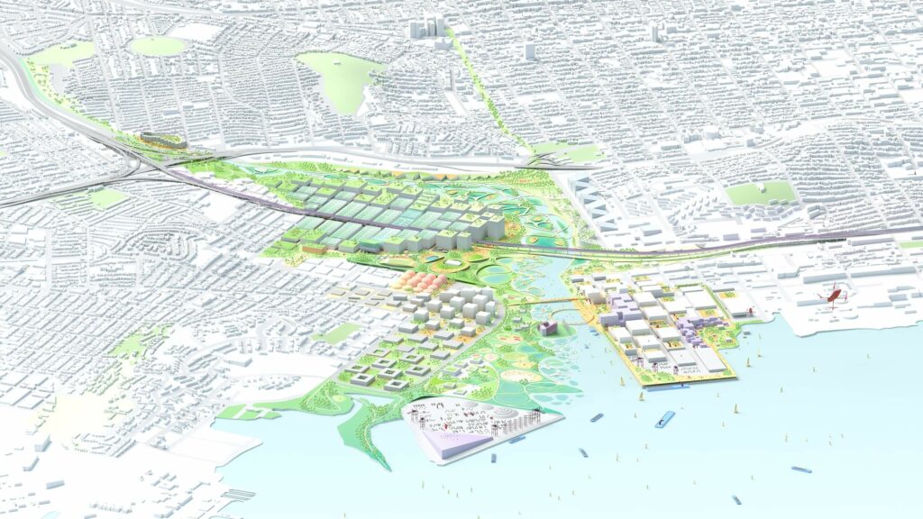
The BIG + ONE + Sherwood team has highlighted six potential pilot projects to kickstart the long-term vision for a resilient Islais Hyper-Creek. These include:

  1. Islais Creek Gateway: At Pier 90, underutilized land can be naturalized into soft shorelines to better handle storm surge, creating a gateway park to Bayview and space for stacked vertical industry and working spaces along the iconic grain silos, kicking off a longer-term naturalization of the creek’s southern edge.
  2. Living Levee: At the Southeast Plant, natural treatment systems can be piloted along the creek, using wetlands to process waste water, and tying in to a future decking of the plant itself, creating space for much-needed recreation, open space, and education opportunities for the neighborhood.
  3. River Park: Along Cesar Chavez Boulevard, existing vehicle yards can be consolidated and stacked in a future district facility, creating space for a daylit creek along its historic path and opportunities for living by the water along its banks.
  4. SF Food District: The San Francisco Produce Market will be modernizing in the future. By incorporating additional functions, it can help kick-off the creation of a future food and clean logistics district in the heart of the basin, where production, storage, selling, and enjoyment of the area’s products come together as a new destination in Bayview.
  5. Living with Water: Alemany Farmer’s Market sits at a critical pinch point in the creek’s flow. Rethinking the site, we can accommodate space for water, doubling as a park, flanked by a new market and space for housing overhead, with adjacent parcels underneath the freeways doubling as parking and water reservoirs.
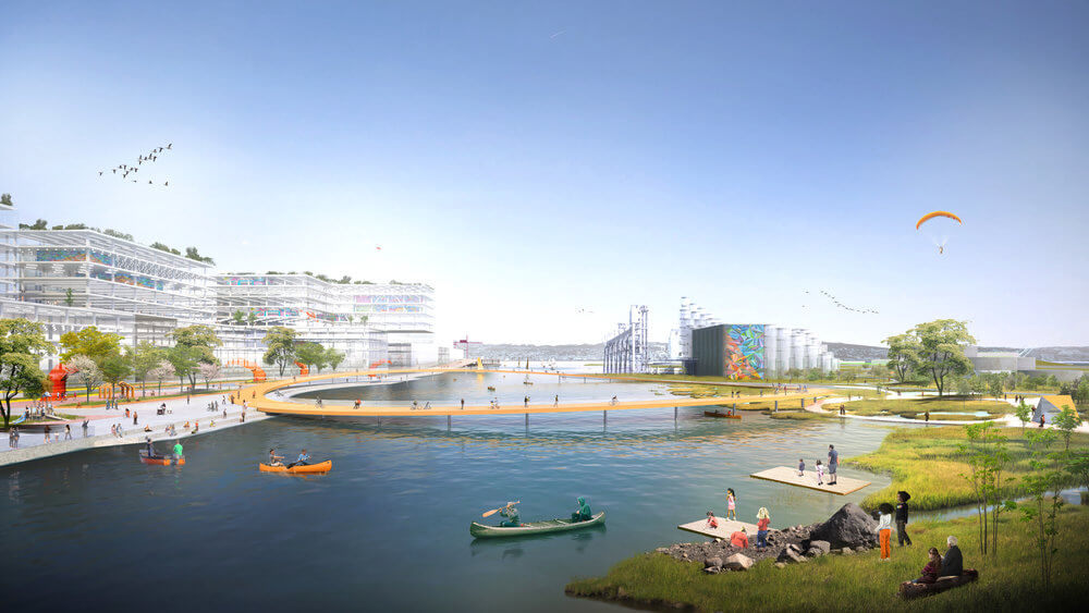
  6. Innovation Cove: At the bay shore, land circling Warm Water Cove can help extend the city’s waterfront network into the southeast, providing a platform for a new innovation dock, local business incubators, research facilities, and experiments in resilient floating architecture form a hub of innovation for the city.

The working group has arrived at these pilots based on their ability to align with various current and planned projects or studies initiated by the City and the Port. This will allow agencies and local organizations to form a planning process around them and be drivers for their future implementation.

Translate